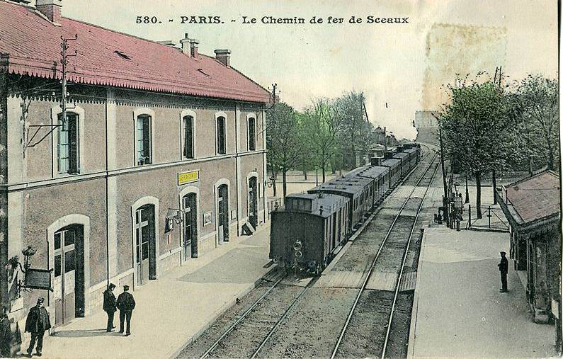
In 1844 Jean-Claude-Républicain Arnoux (1792-1866: As you might guess, he was born just after the French Revolution) acquired the rights to create and run the Chemin de Fer de Paris ŕ Sceaux. This ran from Paris to Sceaux, a small town only 10 km (6 miles) to the South, and was intended to carry both goods and passengers.
The line was built to the broad gauge of about 5ft 11in (1.80 metres exactly), and had a large number of sharp curves with radiuses from 75 to 30 metres. The track was even more demanding at the terminals, which had loops of only 25 metre radius. In 1854 the line was extended to the town of Orsay, necessitating several bridges and a 205 metre-long tunnel. To cope with the severe curves, the passenger coaches and freight wagons were built with pivoting axles, using an articulation system that Arnoux had patented earlier in 1838. (Patent No 8342)
The articulation system was favourably reported on by a special commission in 1839, and the government authorised the construction of a short experimental line at St Munde, near Paris. Experiments on this line were favourably viewed by a second commission, and in 1840 the Academie des Sciences awarded Arnoux the prize for mechanics. This system was however unusable for coupled driving wheels.
Arnoux therefore tried another approach. This was explained by Auguste Perdonnet, the author of "Traité élémentaire des Chemins de Fer" (1860) as follows:
"The two driving axles are mounted close to each other and are coupled by rods. The driving wheels have no flange and their tires are 30 cm (11.8 in) wide. The first and the fourth axle have to support an amount of the weight of the engine and are completed with supplementary almost horizontal guiding wheels. The engines run on curves of 25 metre radius."
Arnoux could only obtain a concession for a line from Paris to Sceaux, (south of Paris) which was not a particularily favourable prospect, as the French goverment did not want to run the risk of an untried system on important routes. The line opened in 1846, after two years of work, delayed by land speculation. It ran from a terminus in Paris (near the present-day metro station Denfert-Rochereau) through Bourg-la-Reine to Sceaux.
It seems very likely that the line was single track, but I have so far not been able to find a clear statement that this was the case. This would seem to imply the need for passing loops, unless the service was rather infrequent, but no evidence for them has been found so far. The waters are muddied by several Paris maps that show the line as double-track.
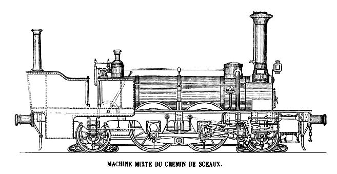 |
| Left: One of the two 2-4-2 mixed-traffic tank engines built with Arnoux guide-wheels in 1855
The flangeless angled guide-wheels are fitted to the first and the fourth axles, which are non-driving. The wheels on the coupled driving axles have tyres almost a foot across, so that contact could be maintained with the rails even when they were severely curved. Even so, the tight curves at stations required auxiliary rails to be installed parallel with the usual ones so the driving wheels could make contact.
Image from: "Traité élémentaire des chemins de fer", Tome second, Auguste Perdonnet; 2e édition; Garnier Frčres, France 1860.
|
The function of the second chimney at the rear is unknown. My own guess is that it was the steam outlet for some sort of feedwater-heating system, like that used in the Sturrock steam tenders. One of these engines was shown at the Paris Exhibition of 1855.
 |
|
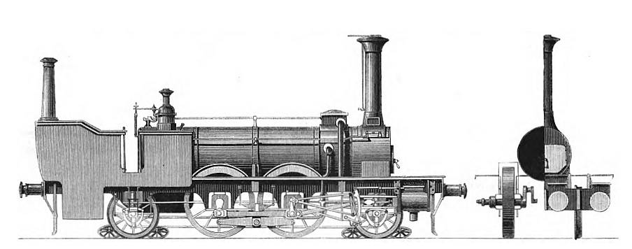
Above: another drawing of the same engine. At the right, note the wide flangeless driving wheels with both inside and outside cranks spaced at 90 degrees. Only the front and rear wheels had flanges. At the extreme right can be seen the arrangement of the cylinders; one inside and one outside of the frame on each side of the locomotive.
Image from: Engineering: An Illustrated Weekly Journal. 1869
|
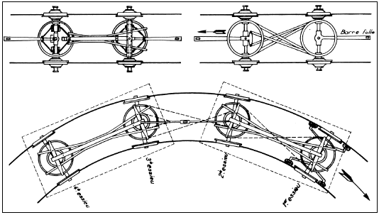
The driving wheels on each side were independently driven, as solid axles would have led to severe frictional losses as the wheels tried to move at different speeds on the sharp curves. This required two cylinders driving each side, with cranks at 90 degrees, to prevent one or both sides of the engine from stopping on a dead-centre.
These two engines were not satisfactory. As the un-named author of the article in Engineering put it:
"These two engines were, from the system on which they were constructed, necessarily complicated, but their complication was increased to a most unnecessary extent by their designers having introduced in them various peculiar details of their own invention, details which, although some of them good in themselves,were out of place on these engines. The inside axle boxes and other parts were very difficult of access, and as a necessary consequence they were not well lubricated and gave much trouble by running hot." Many significant modification had to be made at the Ivry works of the Paris-Orléans Railway.
The locomotive shown below is something of a mystery. The evidence suggests it was built in 1855, but it does not resemble either the drawings shown above, or the locomotives built in 1867, shown further below. The Arnoux principle appears to have been copied by J R Davies of Australia, in locomotives built for the short-lived wooden-tracked Oreti railway of New Zealand.
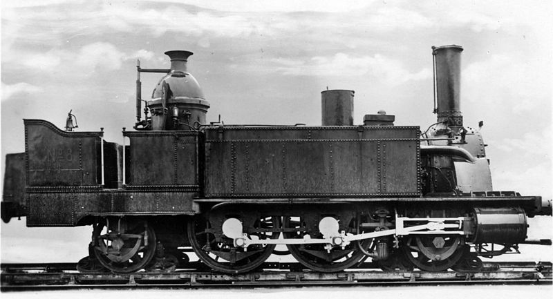 |
| Left: 2-4-2 tank engines with Arnoux guide-wheels built in 1855
This locomotive was constructed by Anjubault of Paris for the Compagnie d'Orsay. It was put into service in 1855, and then modified in 1867. This locomotive was numbered No 8 by the Compagnie d'Orléans.
|
Six more engines were built in 1867, also at the Ivry works of the Paris-Orléans Railway. These had only only two cylinders, and how the problems that required independent drive and two cylinders per side for the earlier engines were resolved is not currently known.
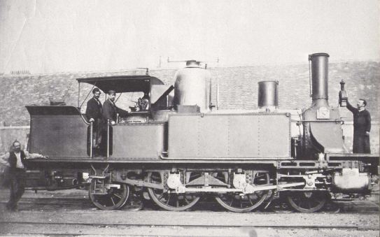 |
| Left: One of the six 2-4-2 tank engines with Arnoux guide-wheels built in 1867
The general style is consistent with that of French locomotives in the 1860s and 70s. The springing of the two driving axles is different from that of the earlier locomotives.
Water was carried in the wing tanks above the driving wheels. There is no second chimney on the tender.
Image kindly supplied by Patrick Jacobs
|
 |
| Left: The Arnoux articulation system for carriages
The Arnoux articulation system used swivelling axles on the carriages, connected together by chains. The carriages were connected by rigid drawbars so the axles would take up a radial position on curves. The wheels rotated freely on each axle to eliminate wheel slip on tight curves. This system is quite independent of the guide-wheel system on the locomotives.
As carriages became longer it was obviously simpler to mount them on two for-wheel bogies.
|
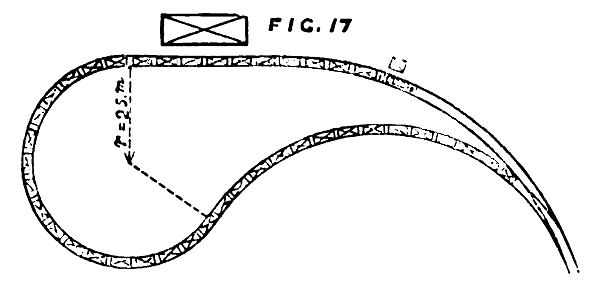 |
| Left: Plan of a terminal station on the line
On reaching the terminus at Paris or Sceaux, the Arnoux locomotive would reverse its direction by running round a loop of track with the very tight radius of 25 metres. This meant there was no need to move the engine from one end of the train to the other. The station buildings were arranged in an arc around the loop.
This drawing appears to represent a single-track layout.
Image from: Engineering: An Illustrated Weekly Journal. 1869
|
For a good part of its history, the Chemin de Fer de Paris ŕ Sceaux operated in splendid isolation from other railways, as it had to, given its non-standard gauge and its very severe curves. Unfortunately there was little traffic; the area it ran through was sparsely populated, and the line had no direct connection to the main railway system, or even a shared station with it. In 1852 permission was granted for an extension from Bourg-la-Reine (a station between Paris and Sceaux) to Orsay, but this proved no more profitable.
In 1846, Arnoux obtained the concession for a line to Orsay and Limours. Given the wealth of the region, the potential tonnage of goods to be transported (mainly for paving the streets of Paris, with stone from Orsay) promised that the line could become profitable. Unfortunately, the economic crisis of 1847, and the riots and revolution of 1848 "plombčrent" the operations (I assume this means "sunk") before completion of the line to Massy and Orsay. The line was then placed in receivership in 1849.

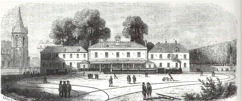
THE PARIS END OF THE SCEAUX LINE
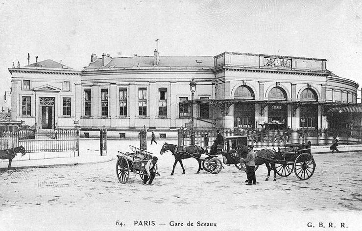 |
| Left: The Paris terminal station of the line: 1906
The terminus at Denfert-Rochereau seen from the street side, in 1906. The building, with its distinctive curved layout, looks much the same today. Note the three-arched entrance hall with canopy.
From a postcard dated 1906.
|
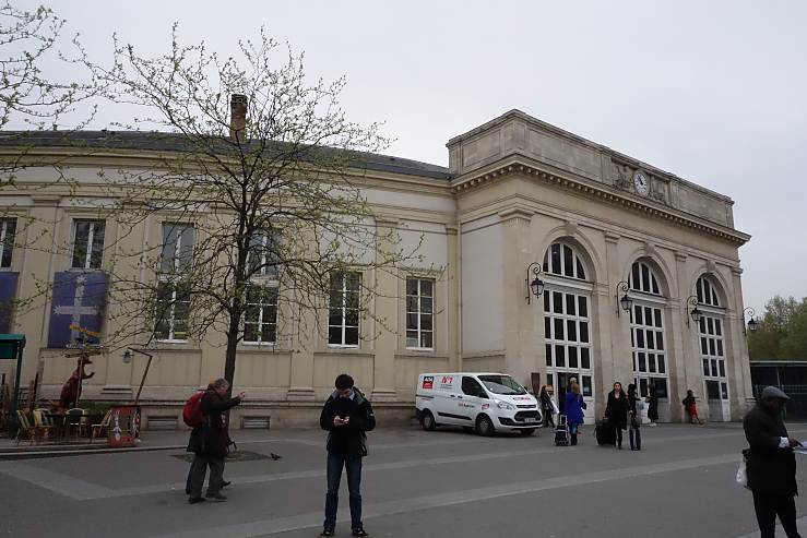 |
| Left: The Paris station: 2013
The terminus at Denfert-Rochereau seen from the street side, in 2013. It is the oldest railway building still standing in Paris. It is in use by the RER B suburban line.
Author's photograph April 2013
|
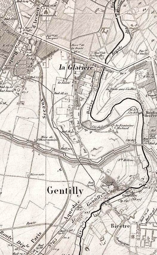 |
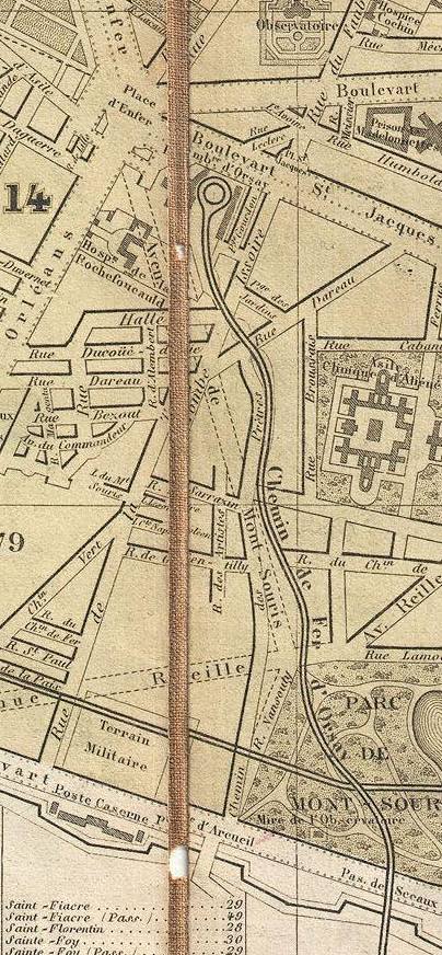
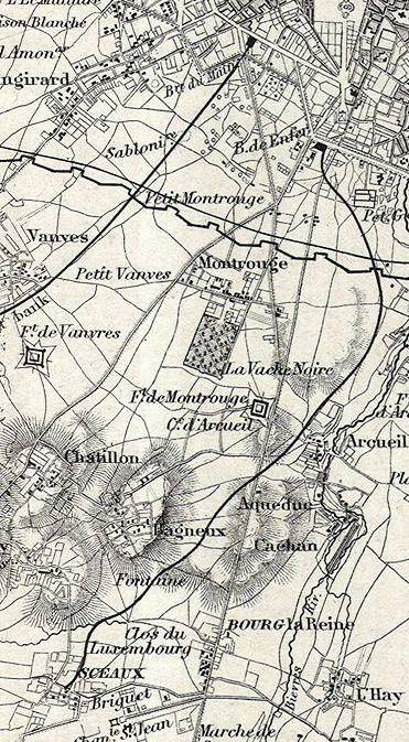
| Left: The Paris end of the line: 1852
The original Paris terminus is marked by the loop of rail at top left, just to the east of what a square that is nowadays called Denfert-Rochereau, though it only acquired that name in 1879. There is a Rue d'Enfer (Road of Hell) running north-east from the square. The line runs through open country almost as soon as it leaves the terminus. It appears to be single-track.
At its southern end the line passes through the 1841 fortifications of Paris, called the Thiers Wall.
This map shows detail lacking from later versions. The Sceaux line enters a cutting just north of the fortifications. Just before it passes through the walls there is a dot that may represent a station. Beyond the walls the line is in cutting again, probably because it was passing through the glacis of the fortifications. A glacis was a earth slope that gave a clear line of fire on attackers and shielded fortifications against direct artillery fire.
The curved body of water to the east is the Bievre river (Beaver River) which does not appear on modern maps as it now runs in tunnel for all of its path through Paris. For a good reference see: parisisinvisible.
Note the aqueduct running almost parallel with the railway, and crossing it just south of the Rue des Catacombes. This is the Aqueduc d'Arcueil, which brought water almost 100 km from the rivers Vanne, Loing, and Lunain, to Paris. This 1852 map shows an early version called the Aqueduc Médicis built on the orders of Mary Medici. The final version was not constructed until 1860, by Eugčne Belgrand.
The Paris catacombs are a story in themselves.
From Goujon's map of 1852, which the earliest so far found that shows the Sceaux line. Wikipedia also has a Goujon map attributed to 1850, but that date appears to be wrong as it does not show the 1841 fortifications.
|
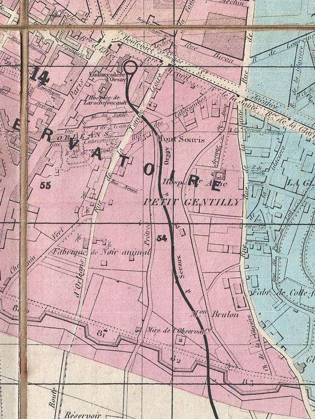 |
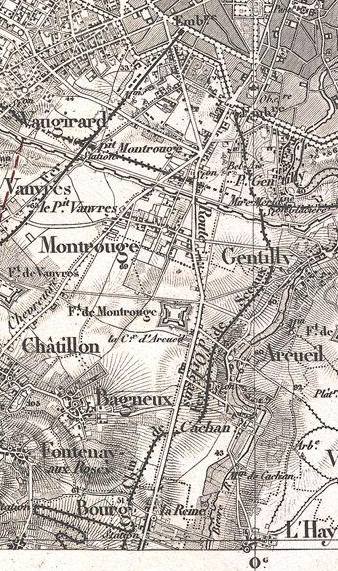
| Left: The Paris end of the line: 1860
The station track layout appears to have changed, adding facilities for trains to go round and round like a clockwork railway. This is probably just a cartographic error.
The line appears to be shown as single-track.
Note the area at the west of the station called the Barriere d'Enfer. This was an entrance through an earlier line of fortifications called the Farmers General Wall, built between 1784 and 1791, initially just as a tariff barrier to enforce a tax on incoming goods called the Octroi; there were later plans to upgrade it for militiary use, but this appears to have never happened. The wall ran along the Boulevard St Jacques which can be seen at the top of the map.
The complex history of the fortifications of Paris can be followed in Wikipedia.
From Goujon's map of 1860.
|
 |
| Left: The Paris terminal station of the line: 186?
A large building is shown just to the west of the station, and the entrance hall is not shown.
Note that the station track layout is different again from the 1860 map above.
This is taken from a Hachette map that Wikipedia dates as 1870, but this must be wrong. (No date is shown on the map itself)
1870 is too late a date, as the map does not show the petite ceinture, a railway line encircling Paris just inside the 1841 fortifications, and originally built for military purposes. The northern part of the petite ceinture was built from 1852 to 1854, but the southern section which would be shown here was not completed until 1867. Similarily, the square adjacent to the station is shown before it was enlarged. The true date of the map is probably around 1860-63.
|
 |
| Left: The Paris terminal station of the line: 1864
The curved station building now shows an entrance hall on the west side, that is not visible on the map above. (This is almost certainly poor cartography on the map above and not significant) The large building to the west of the station has disappeared.
The petite ceinture runs along the bottom, just inside the fortifications. This was (and in places still is) a double-tracked line. The Sceaux line is shown in the same style, but I am not convinced that is correct. Perhaps the cartographer was clumsily trying to portray the broad-gauge track.
The Bievre River (today wholly in tunnel) can be seen to the east.
From Garnier's map of 1864.
|
 |
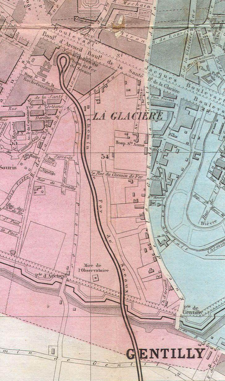
| Left: The Paris terminal station of the line: 1867
This comes from the Logerot 1867 map of Paris, and clearly shows the petite ceinture at the bottom of the map, running just inside the fortifications.The railway is labelled "Chemin de Fer d'Orsay". By this time it had been bought by the Paris-Orléans railway company. Note the Place d'Enfer just to the north-west of the station.
Unfortunately the cartographer seems to have nodded a bit when drawing the track layour of the station, giving us here a completely isolated circle of track. Once again the Sceaux line is shown in the same style as the double-track ceinture, but given the ham-handed attempt at drawing the station layout, I am not persuaded.
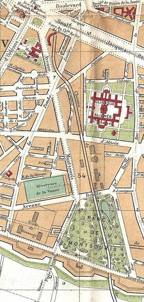
In the south of this map the line runs through the Parc de Montsouris, and crosses the petite ceinture without any connection. The petite ceinture at this date appears to be running on the surface through the park, but it is much more likely that the line was put into tunnel and cutting when the park was built.
The Parc de Montsouris was laid out between 1867 and 1878, long after the two railways were built. The idea was to provide Parisiens with green spaces at the four points of the compass; the Bois de Boulogne to the west, Buttes-Chaumont to the North, the Bois de Vincennes to the East, et Parc de Montsouris to the south.
|
 |
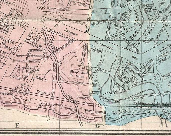
| Left: The Paris terminal station of the line: 1892
This is after the the conversion to normal gauge and normal operation in 1889, so the tight loop at end of the line has disappeared, but the curved station building remains to the west of the line, which is now shown correctly as double-track.
The square to the west of the station was renamed Place Denfert-Rochereau in 1879 after Pierre Denfert-Rochereau, the French commander at the siege of Belfort during the Franco-Prussian War (1870–1871). It is dominated by the Lion of Belfort.
In the south of this map the line runs through the Parc de Montsouris, and still crosses the petite ceinture without connection. The petite ceinture is now shown as running under the park mostly in tunnel, though a short section is in deep cutting.
Almost the entire circular route of the petite ceinture has been disused since 1934. Debate continues as to the best use of the trackbed.
It is notable that the layout of the Parc de Montsouris looks rather different on this map compared with the one above. It is not clear if this is due to radical rearrangements of the park or cartographic inaccuracies.
|
A station called Sceaux-Ceinture was built (date currently unknown) on the Boulevard Jourdan to allow interchange with the petite ceinture which had a station a little to the east called Gare du Parc Montsouris. The line appears to have crossed Boulevard Jourdan on the level. It was replaced in the early thirties by the current RER B station Cité Universitaire, the Sceaux line being lowered so it could run under Boulevard Jourdan, allowing the level crossing to be removed.
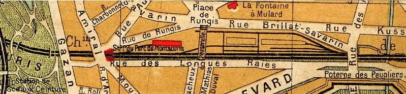 |
| Left: The Sceaux-Ceinture station at Mont-Souris: 1910
This map of 1910 shows the Sceaux-Ceinture station at the extreme bottom left, south of where it crosses the buried petite ceinture. Some distance had to be covered on foot between the two stations.
|
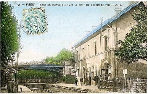 |
| Left: The Sceaux-Ceinture station at Mont-Souris, looking north: date??
This postcard shows the Sceaux-Ceinture station with the level crossing over the Boulevard Jourdan in the foreground. The bridge beyond it carried one of the walkways in the Parc de Montsouris.
|
 |
| Left: The Sceaux-Ceinture station at Mont-Souris, looking south: date??
The level crossing over the Boulevard Jourdan is just beyond the station. Further on, the line passes through the fortifications, which are hidden by the trees on either side.
|
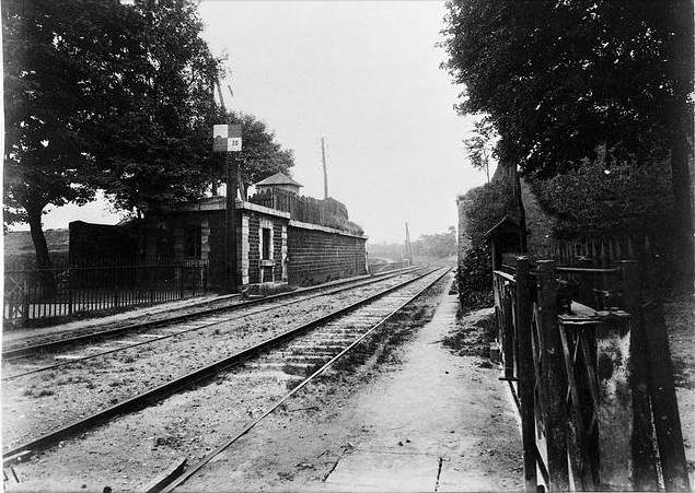 |
| Left: The Sceaux line passes through the fortifications. Looking south
The Boulevard Jourdan is in the immediate foreground. The small building to the left is just visible in the postcard above, between the trees and the train.
Note that there is no attempt to make the gap in the walls defensible. This line of fortifications, called the Thiers Wall had proved ineffective in the Franco-Prussian war and was militarily obsolete. It was however retained for many years to enforce taxation on goods entering Paris. Its demolition did not begin until 1919; its site is now occupied by the Boulevard Périphérique. (Paris ring road)
This is one of a series of photographs of the Paris fortifications taken by Eugene Atget between 1899 and 1913; the exact date is unknown.
|
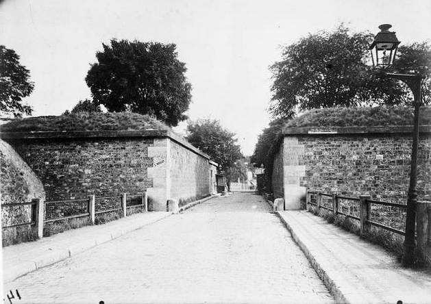 |
| Left: A better view of the appearance of the fortifications
This gate through the fortifications is the Porte d'Arcueil, probably looking north into Paris. It was the gate immediately west of the point where the Sceaux line went through, and can be seen in the maps above.
Very few parts of the Thiers Wall remain. One that does is the Poterne_des_Peupliers (the Postern of the Poplars) which was to the east of the Sceaux gap; it is visible on some of the maps above. See also parisisinvisible
Another photograph taken by Eugene Atget between 1899 and 1913.
|
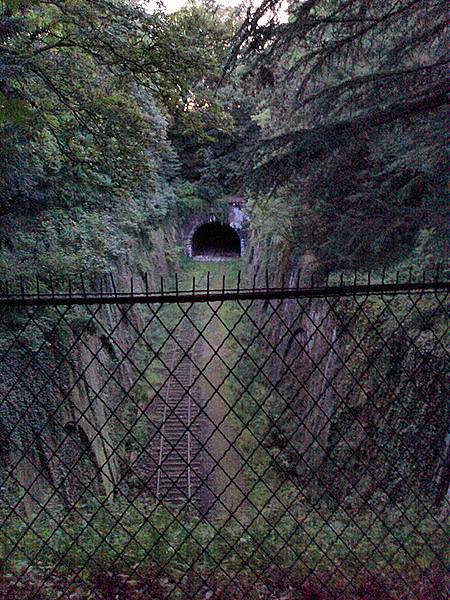 |
| Left: The petite ceinture cutting in the Parc de Montsouris, looking to the west.
This is the present-day appearance. The entire petite ceinture was originally double track.
The route of the petite ceinture is today paralleled by Tramway line T3a running along Boulevard Jourdan. This opened its first section in 2006. It is the first tramway to open in Paris since the closure of the previous tram system in 1937. That opened in 1855, with horse-drawn trams, later powered by steam and then compressed air, and finally electricity. It was running 50 years before the first metro line opened.
|
THE WHOLE SCEAUX LINE
 |
| Left: The entire Paris-Sceaux line: 1855
This comes from the Colton 1855 map of Paris. Sceaux is obviously a small town, and it is hard to see why the promoters of the line thought it would generate much traffic. The other terminus to the north is the Gare Montparnasse of the l'Ouest railway.
Bourg-la-Reine is shown as some distance from the line, rather than as a station on it, and there is no sign of the extension to Orsay. Permission was granted in 1852, but that does not mean construction started at once.
|
 |
| Left: The Paris-Sceaux line: 1852
This comes from the 1852 Depot de Guerre Map of Paris, and looks very diffrent from the map above. Unfortunately Sceaux is off the map to the south, but Bourg-la-Reine can be seen as a station on the line, with some very severe curves just to the south of it. The start of the extension to Orsay can just be seen heading south from Bourg-la-Reine.
The petite ceinture can be seen just north of the fortifications. The 1852 map shows it already completely encircling Paris.
|
 |
| Left: The Paris-Sceaux line: 1852
This comes from a different 1852 map, by Andriveau-Goujon. It shows the twisting approach to Sceaux, with the steep gradient it had to climb indicated by the closeness of the contour lines, and the Bourg-la-Reine station to the east. The extension Bourg-la-Reine to Orsay can be seen branching off to the south, where it enters a cutting and then goes under the Sceaux road in a short tunnel.
Note the church (eglise) just to the south of the station.
|
 |
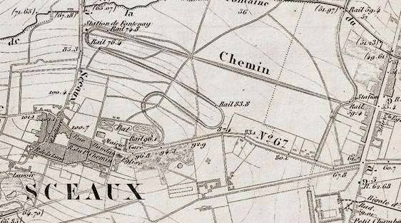
| Left: The station at Sceaux
This is the terminus at Sceaux, with its loop of track. It is identified as Sceaux rather than Paris by the church to the left of the station. The layout is shown as single-track.
The artist has grossly exaggerated the width between the rails, which was 1.8 metres. (5ft 11in)
|
POSTSCRIPT
In 1857 the Chemin de Fer de Paris ŕ Sceaux was bought by the Paris-Orléans company and the line was extended to other towns south of Paris. (an extension to Limours was opened in 1867) In 1889 the French government allowed the conversion to normal gauge. A third rail was therefore installed at 1.435 metres gauge between the 1.75 metre gauge tracks to allow dual use, and on the night of 21 - 22 May 1891 the Arnoux locos and cars were replaced by normal locomotives and cars with four-wheel trucks.
The following appeared in a journal called "Iron" on 26th May 1893:
"THE SCEAUX RAILWAY, one of the most peculiar lines in Europe, has ceased to exist. It connected Paris with Sceaux, a town a few miles south of the French capital. Many were the jokes about the "chemin de fer circulaire," so-called because on arriving at their destination the trains turned round in a complete circle in a garden, and started on the return journey. The carriages were almost like toy carriages, open at the sides, and the engines, which weighed a couple of tons, were specially made for hill-climbing, the gradients being very steep. The line has now been rebuilt, new and powerful engines have been made, and the terminus henceforth will be at the pleasure-resort known as Robinson, about a mile distant."
I must admit I was baffled as to how a small French town could come to be called Robinson; investigation showed it was named after the nearby commune of Le Plessis-Robinson, and the ultimate origin of that name is... Robinson Crusoe. Robinson certainly exists today, about 3 km west of Sceaux. Google maps gives: Robinson, Châtenay-Malabry, France.
The line was extended from its original terminus at Denfert-Rochereau deeper into Paris, terminating at a new station built underground at Luxembourg between 1889 and 1895; an intermediate station was built at Port-Royal. In 1937 it was acquired by the Compagnie du Metro Parisien; since 1977 it has been integrated into the RER B suburban line. The RER system operates like the Metro, but is faster as it has fewer stops. (RER = Reseau Express Regional = Regional Express Network)
The original curved station building at Denfert-Rochereau station still exists, and is the oldest railway building still standing in Paris. The Sceaux-Ceinture station has been replaced by a modern building and renamed Universitaire.
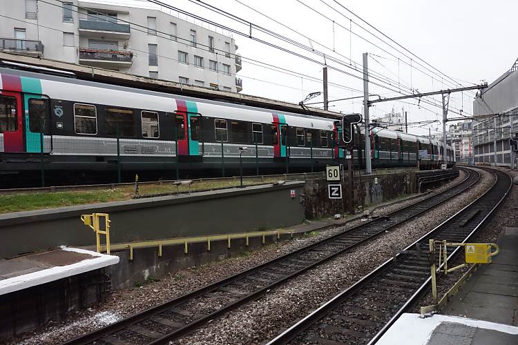 |
| Left: looking south from Denfert-Rochereau station
On the upper left is the area that used to contain the turnaround loop. Some of it is occupied by three sidings, apparently in use for stock storage. The rest of the area has been built over.
The tracks in the foreground are on a down gradient coming towards the camera as the line goes underground just north of Denfert-Rochereau.
Author's photograph, April 2013
|
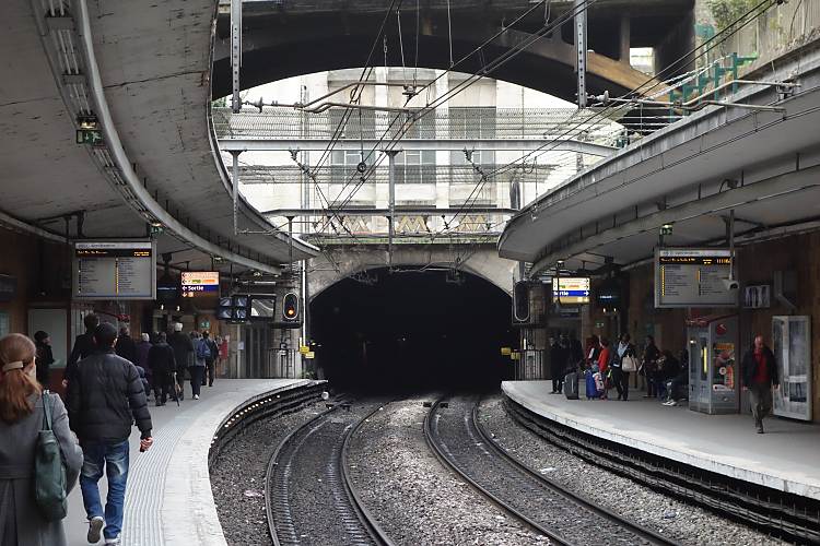 |
| Left: looking south from Universitaire station
This station was originally called Sceaux-Ceinture. The lines are now below street level, and pass under the Boulevard Jourdan and the Universite de Paris, one building of which can be seen in the background.
There are no intermediate stations between Denfert-Rochereau and Universitaire.
Author's photograph, April 2013
|
Remarkably, the Arnoux guide-wheel system is still in use on those parts of the Paris Metro which run on rubber tyres. However, conventional railway track is fitted between the tyre ways, and steel wheels are also fitted; these are normally some distance above the rails and are used only in the case of a flat tyre and at points and rail crossings.


